

|
||||||||||
|
||||||||||
|
Crosswell Seismic Technology Overview
The availability, resolution, and overall quality of crosswell information can significantly impact reservoir management and optimization, as well as the accuracy of reserves assessment.
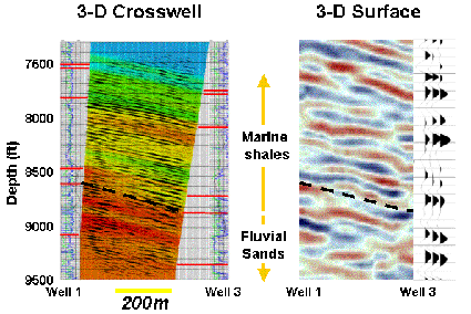
Standard reservoir mapping methods are limited by a lack of data falling between surface and well-bore measurements. While 3-D seismic interrogates large subsurface volumes, it does not provide sufficient resolution for determining reservoir characterization or for monitoring fluids within the reservoir. Well logs and cores do deliver high resolution and precise quantification; but they provide limited information, given that they sample only a small portion of a very large heterogeneous volume. In addition, data accuracy can be reduced by distortion from rocks and fluids encountered during acquisition.
Crosswell seismic imaging is the first technology that fills the information gap between surface seismic and well logs. Applied in a wide range of environments, crosswell seismic enhances the profitable management of subsurface hydrocarbon reserves.
The effective management of subsurface resources requires a true model by which a reservoir's production performance can be predicted -- a model that not only quantifies the reservoir's properties but depicts their distribution as well. Crosswell seismic meets these requirements.
With crosswell seismic, critical reservoir characteristics are directly imaged, not statistically estimated. Faults and stratigraphic features can be clearly identified prior to drilling. Trajectories for in-fill and horizontal wells can be precisely plotted. Fluid movements and saturation changes can be monitored in time-lapse mode. These and other capabilities combine to make crosswell seismic a highly effective tool for managing both resources and risks.
A practical technique for generating high-resolution images, crosswell
seismic draws heavily from proven geophysical imaging technology used
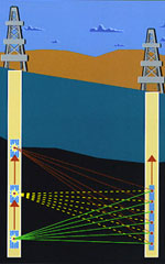
in seismic operations. The crosswell concept is simple: perform the
seismic survey from inside the reservoir instead of from the surface.
A standard wireline technology is used to deploy a seismic transmitter or source into one well and a receiver array, or arrays, into one or more adjacent wells. High-bandwidth data are then collected between the wells, directly across the reservoir or other zone of interest. By imaging from the reservoir, many practical advantages result:
 In the early life of a field, crosswell seismic can simplify the
selection of an accurate geologic model. Its high bandwidth and correspondingly
high vertical resolution (typically 2 to 5 feet) permit imaging subtle
features. For example, a more accurate decision whether to use a tidal
or estuarine model can be made, because crosswell seismic makes such
features as sub-seismic faults, channels, braided streams, pinch-outs,
and reefs "visible."
In the early life of a field, crosswell seismic can simplify the
selection of an accurate geologic model. Its high bandwidth and correspondingly
high vertical resolution (typically 2 to 5 feet) permit imaging subtle
features. For example, a more accurate decision whether to use a tidal
or estuarine model can be made, because crosswell seismic makes such
features as sub-seismic faults, channels, braided streams, pinch-outs,
and reefs "visible."
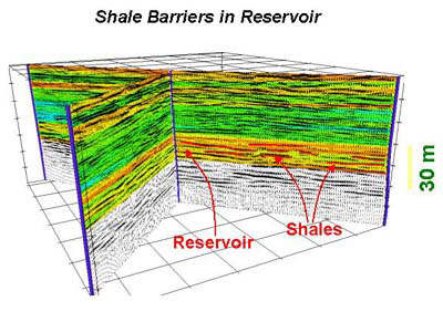
As field development matures, detailed crosswell information can be used to validate or refine the geologic model, identify potentially bypassed reserves, and pinpoint in-fill drilling targets, particularly for horizontal and multi-lateral wells. In conjunction with surface-seismic processing, crosswell seismic can also refine a reservoir's description over a wider area. For example, when crosswell techniques are used to interpret specific reservoir features, it is often possible to develop parameters for processing the surface seismic. The use of these parameters will then enhance the interpretability of targeted reservoir features elsewhere in the field or basin. 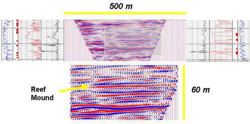
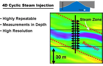
Crosswell seismic provides significant advantages for the time-lapse monitoring of production-related reservoir changes.
Directly referenced in depth, a crosswell seismic survey eliminates the time-to-depth conversions of surface seismic, making it possible to resolve small velocity changes between repeat surveys -- as small as 2 to 3% -- with extreme reliability.
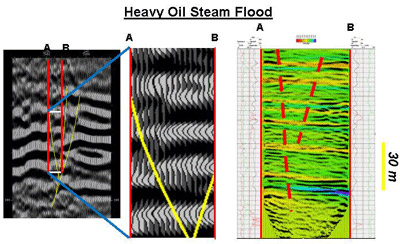
Because seismic velocity changes with reservoir pressure, crosswell seismic permits the imaging of reservoir connectivity and compartmentalization by taking "snapshots" at different pressures.
As with reservoir-description applications, the crosswell monitoring of production and injection programs such as WAG, SAGD, CO2, and steam flooding can also be used to tune and enhance surface 4D studies.
For situations where surface seismic cannot be used, crosswell seismic offers a viable alternative. It is capable of reaching beneath terrain and infrastructure, eliminating many permitting-issues and overcoming gas caps, over-thrusts, salt bodies, and other conditions that can degrade surface-seismic data.
Crosswell seismic can complement 2D, 3D, and 4D operations with accurate, depth-referenced velocity models that enhance the processing and interpretation of surface data. Able to image those small and low-contrast production sub-units, it can help identify reservoir "sweet spots" on a wide-area basis. Due to the unique geometry of crosswell seismic, it is possible to measure TI anisotropy directly, which can be incorporated into the velocity models to improve the results from processing surface-seismic data.
|
||||||||||
|
Visitors
@ Copyrights Reservoir Star International, Inc. 2003-2005 For problems or questions regarding this web contact webmaster@reservoirstar.com Last updated: 07/13/2005 |